Click back and forth on the arrows to get a few different images.
View Larger Map (thanks Andrew)

Click back and forth on the arrows to get a few different images.
View Larger Map (thanks Andrew)
Google StreetView is now available in many cities in France.

Google Image car stops at Wendy’s.
View Larger Map (thanks Aaron K)
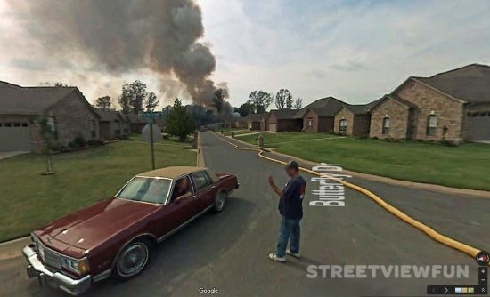
Some images from this area has been removed by Google. The image below show some of the smoke coming out of the house. The burning house is behind the house on this image.
Update: Here’s the scene from another street (thanks Kyle).


View Larger Map (thanks to Dustin)
Submarine USS Cavalla (SS-244) in Houston.
View Larger Map (thanks to VirtualGlobetrotting)
Street View added 37 new cities and parks. They also expanded coverage of 15 cities today.
Here’s the full list
MA: Springfield NY: Buffalo, Rochester, Syracuse NJ: Newark VA: Virginia Beach NC: Charlotte, Winston-Salem SC: Columbia, Greenville GA: Atlanta FL: Boca Raton, Cape Coral, Ft. Lauderdale, Jacksonville, Sarasota, West Palm Beach AL: Huntsville MS: Jackson TN: Knoxville KY: Lexington, Louisville OH: Cincinnati, Columbus, Dayton, Toledo MI: Ann Arbor MO: St. Louis KS: Topeka NE: Lincoln OK: Oklahoma City, Tulsa NV: Reno CA: Bakersfield, Fresno, Sacramento, Stockton Everglades National Park (Florida) Florida Keys Grand Teton National Park (Wyoming) Yellowstone National Park (Wyoming/Montana) Rocky Mountain National Park (Colorado) Joshua Tree National Park (California) Death Valley National Park (California) Lassen Volcanic National Park (California) Sequoia National Park (California) Lake Tahoe (California/Nevada)
Street View coverage has also expanded in 15 of the current areas: Boise, Boston, Kansas City, Miami, Nashville, New York City, Orlando, Philadelphia, Phoenix, Portland, Richmond, San Diego, San Francisco, Tampa, and Tucson. (source)